Update 1: We have our 3rd named storm of the season today. Chantal is expected to head out to sea and is not a threat to land.
[/vc_column][/vc_row][vc_row padding_top=”0px” padding_bottom=”0px”][vc_column fade_animation_offset=”45px” width=”3/4″]Update 2: We just had a new system pop up on the NOAA this morning. The system has a 20% chance of development over the next five days. Currently, it looks to be a rainmaker for Florida this weekend through Monday of next week. Then it’s expected to head out NNW along the east coast. This system could develop as it passes Florida and heads northward along the coast, so keep watching.
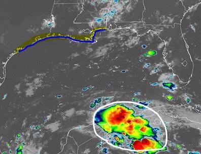
[/vc_column][vc_column fade_animation_offset=”45px” width=”1/4″]Update 3: This is the system I’ve mentioned the last few day that was expected to head into the Gulf later this week. Surprisingly, there’s no mention of it on the NOAA currently. There are some healthy looking storms here. Models are not currently developing the system much as it heads into the Gulf toward Texas and Louisiana over the next few days. We’ll need to watch this system since conditions are favorable in the Gulf for development.
[/vc_column][vc_column fade_animation_offset=”45px” width=”1/4″]Chad Trosper is the AVP of Catastrophe Claims at Tower Hill Insurance. He has over 19 years of experience in the claims industry and a true passion for weather. Chad graduated from the University of Florida with a degree in Business and Sociology and also holds a master’s certification in Business Process Management from the University of San Francisco. Chad currently resides in Gainesville, Florida, with his wife and three children.
