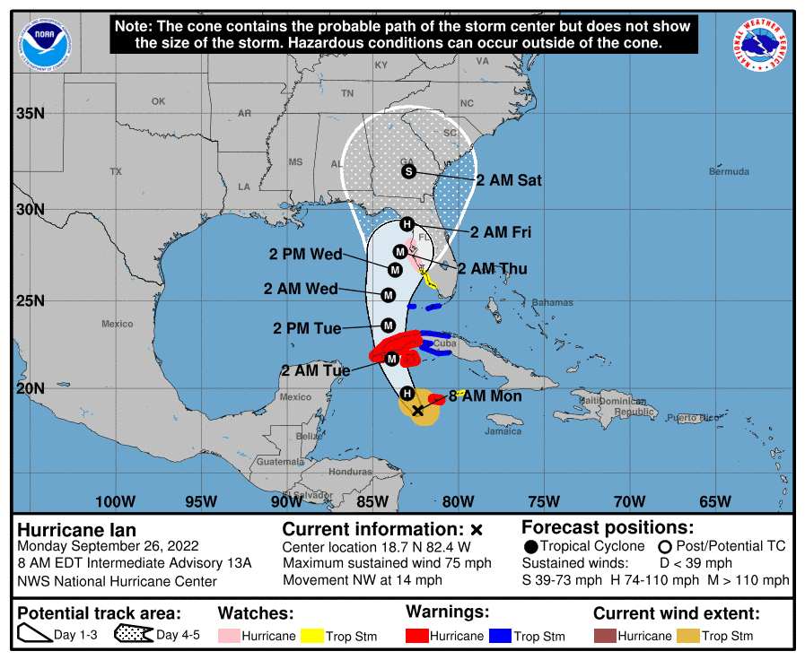
Alright. As I said, there is potential for a push in track more northwest and that’s what we got for sure.

We went from Naples to Cedar Key in 24 hours with a 5-day cone. Well, at least we were all anticipating it, so not a huge surprise. It feels like we’re doing the Cha-Cha Slide.
To the left
Take it back now, y’all
One hop this time
Right foot, let’s stomp
Left foot, let’s stomp
Cha cha real smooth
Anyhow, this is where we are “for now.” Hurricane Ian has winds of 75mph, headed northwest at 14mph. Ian is still expected to blow up as it nears the Gulf and could even reach CAT 4 status once in the mid-Gulf. Yikes. But models do agree that it will start to weaken some as it approaches landfall next week as a CAT 2 or less. So where’s it headed now or “for now?” The National Hurricane Center has shifted the cone far northwest now towards a Cedar Key/Big Bend landfall early Friday morning, potentially brushing the Tampa coastline as it approaches. Will this stick? I imagine we will still see some ups, downs, lefts, and rights come in. So stay tuned folks. It will be interesting.
Let’s go to work
To the left
Take it back now y’all
Two hops this time
Two hops this time
Right foot two stomps
Left foot two stomps
Hands on your knees, hands on your knees
Get funky with it
Oh yeah
Come on, cha cha now y’all

Chad Trosper is the AVP of Catastrophe Claims at Tower Hill Insurance. He has over 19 years of experience in the claims industry and a true passion for weather. Chad graduated from the University of Florida with a degree in Business and Sociology and also holds a master’s certification in Business Process Management from the University of San Francisco. Chad currently resides in Gainesville, Florida, with his wife and three children.